The Place of the Turkey
02 Dec 2023
The Pinhoti Trail offers 335 stunning miles through the Appalachian Foothills
Photos and Story by BRENDON VOELKER
The sound and perpetuity of the waterfalls is intoxicating. Hundreds of miles from the northern trailhead, the Pinhoti Trail works its way south through the foothills of the Appalachians. Though you’ve been on singletrack for some time, the trail opens up as you make your way across an unpaved forest service road illuminated by the moon. As it begins to rise, the bright glow often negates the need for headlamps through the night. The snakes return to their homes, the distant car traffic comes to a halt, and you’re left to enjoy Alabama’s most remote forested areas on your own terms.
Originating from the Creek Nation, Pinhoti is an indigenous word that translates to “place of the turkey.” Nearly 4-inches in height, a painted turkey foot rests upon a white diamond blaze marking the next waypoint on the trail. Meandering in and out of each wash, the oaks, pine, and maple offer one final glimpse of fall color as it transitions to cooler temperatures. Some of the blazes have even been overtaken by tree bark beginning to envelop their sides.
The trail winds through endless contours, crossing solemn creeks, quiet ponds, and bluffs near its highest points. You plunge into every wash, pull a 180-degree turn and typically climb your way out the opposite side. It’s easy to approach thru-hikers unexpectedly due to the trail’s quietly shielded contours and, except when it’s raining, it’s rather dry with just a layer of leaf litter and pine needles blanketing the ground. Fall and winter yield the most popular times for views, though every section of the trail can be hiked year-round.
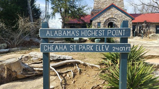
Heading south, you summit the highest point in Alabama, Mount Cheaha, which towers several miles beyond the Talladega National Forest and rises as a grandstand some 2,400-feet above sea level. While it may not stack against Mount Mitchell, the highest point east of the Rockies, the view is spectacular from the state park. Fall colors paint the horizon as October nears November, and you ponder how such an unsuspecting state line dotted with Dollar Generals and quaint churches yields fall colors that rival North Carolina.
Interestingly, there is a bit of a disconnect between traditional Appalachian Trail hikers and the modern thru-hikers. If you look at a map, it’s easy to link the 330-mile Pinhoti to the start of the Appalachian Trail in Springer Mountain, Georgia. Yet, why don’t the trails link together, and why doesn’t the Appalachian Trail begin in Sylacauga? Well, in short, it’s because that’s not what Benton MacKaye envisioned when he sat at Harper’s Ferry and penciled the ideas for the AT in the early 1900s. Its completion marked one of the first long-distance hiking trails in North America. Today, you can find a plethora of them spread across the country.
The name Pinhoti implies an abundance of turkeys, but you will likely encounter other wildlife as well. Though unlikely you’ll need it, bear spray is a great investment if visiting any section of the trail. Bear sightings are uncommon, but winged animals are the opposite. Snakes can also be found on some stretches of the trail, notably an area referred to as Snake Creek Gap further north on the trail in Georgia. Copperheads and Timber Rattlesnakes top the list.
The Pinhoti Trail may be one of the rarer trails on the east coast outdoor adventurers explore, but only because few have heard of it. The trail is new compared to other long trails in North America. Glancing at a map, the southern terminus of the Appalachian Trail begins in Amicalola Falls State Park. Heading westward, the Benton MacKaye Trail migrates southwest into North Georgia to link up with the Pinhoti near Mulberry Gap in Ellijay. Although a popular destination for mountain bikers, hikers, and trail runners alike, only the Georgia portions of the trail allow mountain bikes.
From there, the Pinhoti meanders south through the state before linking up with a paved greenway path along the border with Alabama. In Georgia, you may recognize the Silver Comet Trail that begins west of Atlanta, while Alabama residents may recognize its westward extension, the Chief Ladiga Trail. This paved path is a popular day trip for road cyclists in Atlanta. Interestingly, because the trail crosses state lines, you’ll encounter a time zone change that is easy to overlook. Make sure to factor that into your planning if you’re making a day trip from one state to another.
Likely the most famous event to occur on the Pinhoti Trail is the Pinhoti 100, a 100-mile foot race connecting Heflin to Sylacauga. A qualifying race for larger events such as Western States, its point-to-point status obviates the need for runners to retrace their steps at any point. The Snake is another popular race amongst mountain bikers just outside of Dalton, GA. Several other annual events occur near Mulberry Gap Adventure Basecamp.
As a finisher of the Pinhoti 100, and frequent visitor to the Georgia segments, I can say that the last few miles of the Pinhoti require hikers and runners to dig deep, fight through solitude, and push through pain to meet the time cutoff. That said, every section is open year-round and can be enjoyed at your own pace, rather than with the time constraint of an event. In Sylacauga, the race director hands out finisher awards, typically a golden belt buckle with the race logo engraved, and professional photographers take photos. It is also common for participants to nap on the high school football field where the race ends.
To put the event in perspective, I finished 34th of 280 starters, and it took nearly 26 hours. If planning a thru-hike of the trail, it could range anywhere from a couple of weeks, to several weeks depending on fitness and pace. Most sources consider the trail on the more difficult side, though there are options to visit trail towns and resupply, as well as water on the trail to filter.
Construction of the Pinhoti Trail began in 1970, and the trail was officially opened in 2008. A newer southern terminus at Flagg Mountain extended the trail further south in 2015. It’s comparable in difficulty and terrain to the Foothills Trail near the plateau, other than the length of course. An easy access point for those traveling can be found along Interstate 20 within Talladega National Forest. It’s less than a 15-minute detour, and there is abundant camping nearby for those interested.
A safe and well-established trail to explore, you may make friends along the way, which is especially good during longer runs, hikes, or bike rides, where the solitude and the long stretches away from civilization can be challenging. During the 2017 Pinhoti 100, I paired up with a runner about 10 miles into the race, and we didn’t part ways until mile 65 in the middle of the night. It was one of the most challenging things I’ve ever done, but the trail offers an incredible show of Southern Appalachian beauty and a raw silhouette of color that can only be truly understood in person.
What really makes the Pinhoti special is arguably its lack of visitors and remote settings. North of Ellijay, the trail skirts around the Cohutta Wilderness, offering excellent opportunities for shorter backpacking routes. To the south, the Dugger Mountain Wilderness hosts the second-highest point in Alabama. Further south of Interstate 20, the trail also tours Mount Cheaha State Park. The iconic Talladega Motor Speedway is near the trail, though far enough that it doesn’t disturb its peaceful nature.
Along with the Foothills Trail of North Carolina and Georgia, the Pinhoti Trail tends to rank as one of the safest, best maintained, and easy trails to follow. Compared to NC laws regarding trail markings in some areas, nearly all of the Pinhoti is well-marked. Plan a day trip, thru-hike, backpacking trip, or simply explore one of several waterfalls on the trail this winter. The nearest access point is less than three hours from the plateau, keeping sections of the trail within reach of a day trip as well.