Exploring The Wild
04 Oct 2023
Navigating the Shining Rock wilderness
Story and Photos by BRENDON VOELKER
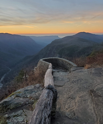
Thunderheads roll across the horizon as you peer through a row of blackberries, blueberries, and mountain ash some 6,000 feet above sea level. You see flashes of light in the distance, and you quickly realize that the top of the mountain is not the place to be on a summer afternoon at 3:30 p.m. An outcropping composed heavily of quartz, you’re standing atop what some may consider a half-acre lightning rod just waiting for the clouds to descend. But don’t let this deter you. While midday summer may not be the ideal time to explore North Carolina’s Shining Rock Wilderness, Pisgah’s largest designated wilderness area, there are endless, year-round opportunities.
Although the term “wilderness” is typically used to describe wild, remote, or untouched areas, the designation from a conservation standpoint is quite unique. Protected under the Wilderness Act of 1964, the US Forest Service notes how “these lands are affected primarily by the forces of nature, where natural biological and physical processes are allowed to proceed with little to no human intervention.” By law, wilderness areas in North Carolina prohibit motorized equipment, vehicles and bicycles, and limit group sizes.
Western North Carolina is home to two of the state’s four national forests. Nantahala encompasses the plateau and continues westward, and Pisgah surrounds Asheville. Nantahala, a Cherokee word describing the sheer cliffs and deep gorges you’ll encounter within its boundaries, serves as the largest National Forest in the state. It is home to three designated wilderness areas, Southern Nantahala, Joyce Kilmer, and Ellicott Rock; Pisgah is home to three of its own, Shining Rock, Middle Prong, and Linville Gorge.
There are multiple considerations and consequences to designating an area as wilderness. In general, wildfires are fought using traditional tools such as rakes and crosscut saws; timber harvesting is prohibited; and restrictions on search and rescue resources are in place. As an example, a fire that begins in a wilderness area will burn until it reaches a wilderness boundary or encroaches upon adjacent structures or buildings.
In recent news, a plan to propose and implement more designated wilderness areas in North Carolina National Forests has been introduced and presented for public response. While the Forest Service has done an excellent job explaining common misconceptions about the status as a wilderness area, it faces opposition from many groups. For example, in areas where hunting is allowed, vehicle access would become limited.
Planning a trip in a wilderness area requires elaborate planning and navigational experience and should not be underestimated. By law, there are no signs, no trail markings, and often no cell reception, making navigation by map and compass the only dependable ways to orient yourself. Modern phone and GPS devices can also aid visitors in the backcountry, but should you run out of battery or drop your phone over a rock, your only option for orienteering will be an analog map and compass.
Emergency equipment such as additional clothing for foul weather, a GPS tracker to share your location, and a water filter are just a few of the many items you’ll want to make sure to pack for your adventure. Most local outfitters are eager to help you prepare for your trip. It is a worthwhile investment to take the time to pay them a visit and get the appropriate supplies.
NC’s wilderness areas hold many treasures and are host to countless iconic trails. Southwest of Franklin, the Southern Nantahala Wilderness area contains a stretch of the 2,200-mile Appalachian Trail before arriving at Winding Stair Gap, the 110-mile mark of the trail. Each spring, ambitious thru-hikers begin their hike at Springer Mountain in Georgia as they make their way towards Mount Katahdin in Maine. Franklin serves as one of the first major trail towns where hikers can resupply along their trek and grab a cold beer at one of the local breweries.
Between Brevard and Waynesville, the 31-mile Art Loeb Trail spends about 10 of its 30-mile journey in the Shining Rock Wilderness traversing 6,000-foot ridgelines. The remote setting, abundant campsites, plentiful water sources, and scent of the evergreen spruce and fir trees make the trail one of the more sought-out destinations in this corner of Pisgah.
Northeast of Asheville in Linville Gorge, a different experience awaits: a narrower corridor along the river where rock climbing is the activity of choice. Considered one of the most coveted climbing areas in the southeast, there are single and multi-pitch climbs that one could spend years exploring.
No matter how you enjoy the outdoors, our state’s wilderness areas are protected to preserve their character, prohibit mining and logging, and to offer a unique experience to all levels of adventurers. Rare plants, wildlife, and unparalleled views also await visitors, and as always, practice Leave No Trace ethics, leave only footsteps, and take nothing more than pictures.