America’s Most Beautiful Drive
04 Apr 2024
The Blue Ridge Parkway awaits
Story and photos by BRENDON VOELKER
It’s April 1st, and jokes aside, we are all fervently hoping the winter weather is fully behind us. Although another stray storm may tease the plateau, it’s safe to say that warmer temperatures are ahead, even if not arriving quite as quickly as we would like. For some, the arrival of spring means time in the garden. For others, hikes and visits to waterfalls. But there is a wonderful opportunity you may not have considered: a drive along America’s most stunning parkway.
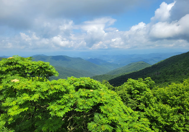
If you enjoy a relaxing and scenic drive, it’s time to fuel up and head for the Blue Ridge Parkway, an experience that offers something for everyone in the family. Considered one of America’s most scenic drives, you can experience the spring rhododendron blooms, the lilies through the summer, mountain ash of the fall, and the long-reaching views of winter.
With over 15-million visitors in 2022, the parkway boasts the title as the longest linear park in the United States. While often confused as the largest national park, it’s technically a national parkway. What began as an ambitious undertaking in 1933, following Virginia’s Skyline Drive in Shenandoah National Park, became something even grander.
The initial budget for the project was $16 million. Although that number may reflect the cost of some of the plateau’s finest homes now, the inflation rate takes that number to nearly $400 million in today’s value. Granted, the project’s forecast was ultimately revised in many aspects. Today, a full-time staff is stationed along the roadway in key areas to answer questions and prune the landscape. Park rangers also patrol the roadway for safety. The maximum speed limit throughout the parkway is 45 mph, and there are several sections where it is lower. For safety, and to allow visitors to enjoy the views, these speed limits are strictly enforced.
In the early days, the initial roadway was intended to take a much more northern route through the Unaka Mountains but, through lobbying efforts, the passage was moved closer to Asheville as the city was in an economic downfall following the Great Depression. The northern route was to cross the Unaka Mountains and lead into the Great Smoky Mountains National Park but was routed through town instead.
Today, Unaka Mountain Road is a 12-mile unpaved road tracing the ridgeline across the mountaintop with endless wildflowers, photo opportunities, and campsites along the Appalachian Trail. It remains a popular destination for professional photo shoots with Erwin, TN as the closest city. One central area on the road has become known as the Beauty Spot.
By World War II, the road was nearly 320-miles long and about half complete. By the mid-1950’s, an initiative was put in place to have the roadway completed by 1966, marking the 50th anniversary of the program’s inception. From a labor standpoint, work was split between multiple agencies. Most of the construction was done by private contractors, but a variety of New Deal public works programs were also employed, including the Works Progress Administration (WPA), the Emergency Relief Administration (ERA), and the Civilian Conservation Corps (CCC).
Due to environmental concerns, the final segment of the Parkway wasn’t opened until 1987. Possibly the most recognized section of the entire 469-mile drive, the Linn Cove Viaduct passed through delicate and rare ecosystems, leading to extreme opposition from environmental conservationists. The adjacent Grandfather Mountain that the roadway passes around is also home to 16 distinct ecosystems and dozens of rare or endangered plant and wildlife species. Its completion marked one consecutive motorway from Cherokee, NC to Front Royal, VA, less than 90-minutes from Washington, D.C.
The sheer beauty of the roadway cannot be overstated. Rhododendron and mountain ash fill the understory at higher elevations; aging hemlock, oak, pine, maple, and birch abound; bear sightings around Asheville are plentiful as the bears often migrate up from the lower neighborhoods to scavenge for food. Deer are also common in areas, and the selection of avian life is quite profound. A field reference guide is an excellent investment and commonly found at many state parks and local outfitters. Monarch butterflies also vary in frequency each year, but if you catch it at the right time, the display is spectacular. Be mindful driving, however, as there are a seemingly endless number of tunnels that require you to slow down and turn on your headlights.
From west to east, the Parkway can be divided into four distinct segments: Pisgah, Plateau, Highlands, and Ridge. The first, Pisgah, is the one many of us know and love and the destination most visitors from the plateau should try first. Beginning in Cherokee, near the entrance to the Great Smoky Mountains National Park, the Parkway meanders its way through the Qualla Boundary, an area set aside for the Eastern Band of Cherokee Indians (EBCI), and the only remaining Cherokee reservation west of the Mississippi.
The roadway quickly climbs into a southern-Appalachian spruce-fir forest nearing 5,000-feet, then makes its way to Waterrock Knob. A highlight of this region, this towering overlook offers views to both the east and west, making it an ideal destination for a sunrise or sunset. A visitor center and restrooms are also available in the warmer months.
Importantly, the park’s policy on overnight camping is vague, leading many camper vans to pursue a quiet overlook for the evening. Even so, rangers have stated that some of the easily accessible overlooks have been subject to crime, particularly the defacing of infrastructure and the disturbance of critical landscapes, so visitors should take care.
If visiting from Highlands or Cashiers, the closest places to jump on the scenic road are Balsam Gap between Waynesville and Sylva or the southern terminus in Cherokee. Less than 90 minutes to either, you can hop on and drive as far as you’d like. A common option is to get on at Balsam Gap and drive to Asheville, especially if planning a trip to the Biltmore Estate during your visit. The Parkway crosses a road just minutes from the estate and offers plenty of options for dining and a wide range of accommodations.
When it comes to driving the Parkway, the speed limit generally sits at 45 mph or less with overlooks rarely more than five minutes apart. Although most overlooks are cleared for the sweeping mountain views, some have been abandoned or neglected to allow nature to reclaim the land. There is no doubt, however, that the Parkway allows for some of the state’s most astounding mountain views by car with a minimal impact to the environment, the essence of the Cherokee word “Cataloochee,” meaning “waves upon waves of mountains” or “fringe standing erect.”
In addition to the low speed limit, you’ll also notice that the Parkway contains no painted lines along the outside of the road. This was done to maintain the wild and natural feel of the environment by limiting impact on nature’s aesthetics. The roadside barriers and guardrails are also built using a natural wood construction, much of which is rumored to come from the area.
For details on road conditions, openings, and questions regarding the road, a central visitor center is located near Asheville and can be contacted by phone at (828) 298-5330. A road conditions page is also available at www.nps.gov, a critical resource if attempting to drive in the winter or following major weather events. Be sure to bookmark it on your phone before you leave, as cell reception doesn’t exist in all areas. Some sections near Asheville and Roanoke tend to stay open year-round, though closures are frequent in the winter as they don’t salt or treat the road in order to preserve its longevity.